Geobotanical zoning, the delineation of zones and subzones of vegetation, is important for ecological and climate studies, facilitating the understanding of natural patterns and processes at different spatial scales, as well as allowing the comparison of ecosystems, the study of their dynamics and the assessment of their responses to environmental changes. The boundary of the subarctic and arctic tundras (High and Low Arctic) is recognized by Arctic researchers as fundamentally important. The widespread use of different regionalization schemes in research raises the following questions addressed in the article: (I) What general criteria define this boundary? (II) Can anthropogenic influences significantly change the distribution of these criteria? (III) Is the widely accepted temperature criterion still relevant given ongoing climate change? and (IV) Is it possible to determine the boundary of subarctic and arctic tundras by mapping these criteria based on modern open climate data and Earth remote sensing data?
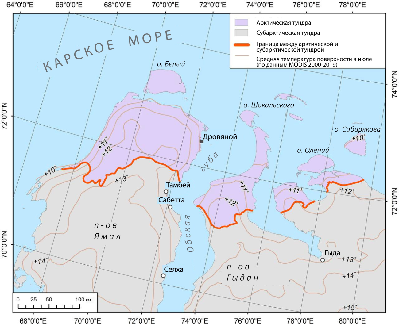
The analysis of scientific publications showed that researchers rely on general criteria when marking geobotanical boundaries in the Arctic. Circumpolar criteria are based on vegetation structure and climate, while regional characteristics are reflected by floristic criteria. Published designs vary widely, making it difficult to compare scientific results. Maintaining the general principles of geobotanical zoning, the authors drew the boundary between subarctic and arctic tundras using current field data and modern techniques: species distribution modeling (SDM), processing of radar, thermal and optical satellite sensing data, and analysis of climate data. The tundra zone of Western Siberia was chosen as a model in this study, where special studies had not previously been carried out to determine the exact location of geobotanical boundaries.
Analysis of existing zoning schemes revealed four main criteria used to determine the geobotanical boundary under consideration: the distribution of key species, the northern limit of the distribution of shrubs and dwarf shrubs over 15 cm in height, the northern limit of the distribution of communities dominated by Betula nana on watersheds, and the July isotherm of +6° C. All these criteria can be mapped with high accuracy using modern data and methods. The developed zoning algorithm, based on a set of analytical methods, takes into account ongoing climate changes and anthropogenic impact. It represents a significant improvement over previous speculative approaches by allowing detailed mapping of this geobotanical boundary for the entire Northern Hemisphere.
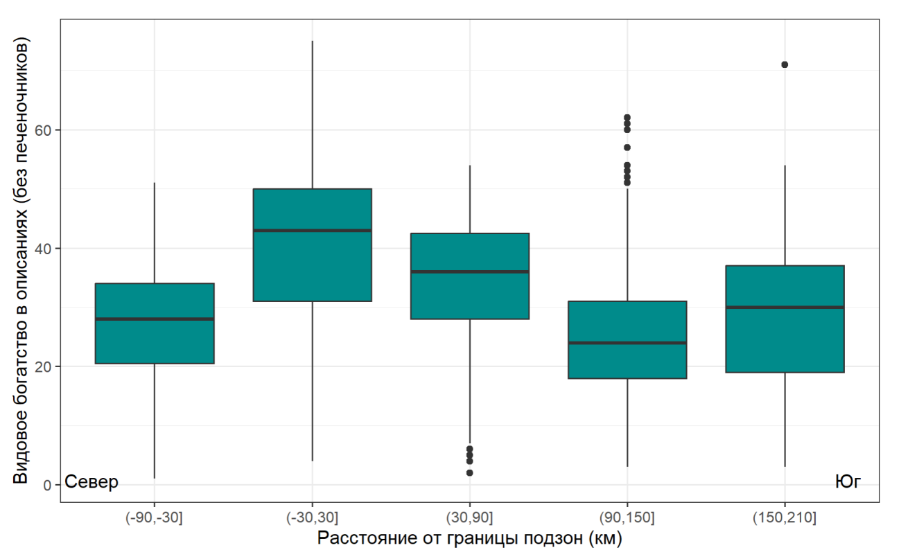
Given the irrelevance of the temperature criterion, previously widely used, revealed in this study, it is proposed to use three biotic criteria that have shown their relevance. The research emphasizes that local industrial impact does not change the distribution of criteria at the scale of the study, while activities that transform large areas do. as reindeer grazing may influence the distribution of criteria based on vegetation characteristics, with minimal impact on the distribution of key species. It has been shown that the boundary between the subarctic and arctic tundras on earth is about 60 km wide and is reflected in the distribution of vegetation species diversity by a characteristic peak, because in this transition zone, plants and lichens coexist with northern and southern habitat optima.
Ermokhina, K.A., Terskaia, A.I., Ivleva, T.Yu., Dudov, S.V., Zemlianskii, V.A., Telyatnikov, M.Yu., Khitun, O.V., Troeva, E.I., Koroleva, N.E., Abdulmanova, S.Yu . (2023). The High–Low Arctic boundary: How is it determined and where is it located? Ecology and Evolution, 13, e10545. https://doi.org/10.1002/ece3.10545
Ermokhina, K. A. – senior researcher laboratory of biogeocenology
Ivleva, T. Y. – graduate student of the laboratory of biogeocenology